
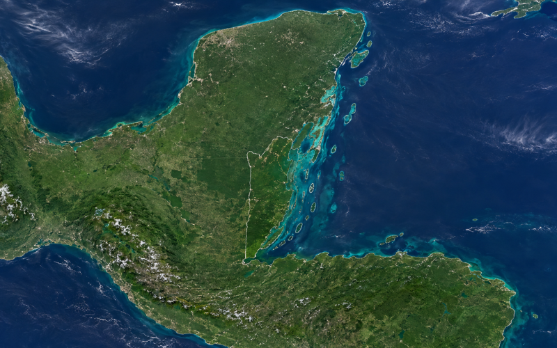
Where is Belize? Belize is a small country in Central America, located along the western edge of the Caribbean Sea. It shares a border with Mexico to the north and Guatemala to the west and south, while its eastern side faces the warm waters of the Caribbean.
Although Belize is geographically part of Central America, it is also closely connected to the Caribbean region through its history, culture, language, coastline, and islands. This combination gives Belize a distinct identity compared with many of its Central American neighbors.
On a world map, Belize can be found just south of Mexico’s Yucatán Peninsula and east of Guatemala. It is a relatively small mainland country with a long Caribbean coastline and numerous offshore cayes.
Understanding the location of Belize is easier when you look at its neighboring countries, surrounding waters, major cities, and geographic regions. This guide explains exactly where Belize is located and how it fits into Central America, the Caribbean, and the wider North American continent.
Belize’s Location on the World Map
Belize lies on the northeastern coast of Central America. The country is positioned between Mexico, Guatemala, and the Caribbean Sea. Its approximate central geographic coordinates are 17°15′ north latitude and 88°45′ west longitude.
These coordinates place Belize in both the Northern Hemisphere and the Western Hemisphere. It is north of the equator and west of the Prime Meridian.
In terms of continents, Belize is part of North America because Central America is generally considered the southern portion of the North American continent. More specifically, Belize belongs to the seven-country region known as Central America, which connects Mexico and the rest of North America with South America.
Belize is much closer to the southern United States and Mexico than it is to South America. Looking at a map, you can find it on the Caribbean side of Central America, directly below Mexico and immediately east of Guatemala.
Belize’s Place in Central America and the Caribbean
Geographically, Belize is a Central American country. Central America consists of Belize, Guatemala, Honduras, El Salvador, Nicaragua, Costa Rica, and Panama. Belize occupies the northeastern edge of this region.
Belize has a strong Caribbean identity because its entire eastern coastline faces the Caribbean Sea. The country also has many offshore islands, locally known as cayes, and is closely associated with Caribbean culture and history.
Belize is also distinctive because English is its official language, unlike most neighboring Central American countries, where Spanish is the main official language. Belize’s British colonial history and diverse population have helped create strong historical and cultural links with the English-speaking Caribbean.
For this reason, you may see Belize described as both a Central American nation and a Caribbean country. There is no geographic contradiction. It is a mainland Central American country with a Caribbean coastline and deep regional connections to the Caribbean.
Countries and Waters Bordering Belize
The location of Belize becomes especially clear when you look at what surrounds the country.
Mexico to the North
Mexico borders Belize to the north and northwest. Belize sits directly south of Mexico’s Yucatán Peninsula. The Mexican state of Quintana Roo is on the other side of much of the northern border.
This location places Belize close to southeastern Mexico and the wider Yucatán region. On a map of Mexico and Central America, Belize appears as a narrow country tucked between southeastern Mexico, Guatemala, and the Caribbean.
Guatemala to the West and South
Guatemala borders Belize along its western and southern sides. This is Belize’s longest major land-border relationship and helps define the country’s inland geography.
Western Belize includes forested and hilly areas, especially around the Cayo District, while the southern border separates Belize from eastern Guatemala.
Caribbean Sea to the East
The entire eastern side of Belize faces the Caribbean Sea. This coastline is a major feature of the country’s location and explains why Belize is strongly associated with the Caribbean.
Beyond the mainland coast are numerous cayes and reef areas, including parts of the Belize Barrier Reef. These offshore features extend Belize’s geography farther into the Caribbean Sea.
Where Belize Sits in Relation to the United States
Belize is located south of the United States and southeast of most of Mexico. Follow Mexico down toward the Yucatán Peninsula on a map, and Belize appears directly below its southeastern edge.
The United States does not share a border with Belize. Mexico lies between much of the continental United States and Belize.
Belize is nevertheless relatively close to the southern United States, Gulf Coast, and Florida compared with destinations farther south in Central or South America. Its location in northern Central America puts it much nearer to the United States than countries in the southern half of South America.
It is also worth clarifying that Belize is already geographically part of the North American continent. Central America is the narrow southern region that connects the larger northern part of North America with South America.
Belize’s Location Compared With Nearby Destinations
Belize can sometimes be confused with nearby countries and Caribbean destinations. Comparing their locations makes the geography much easier to understand.
Mexico lies immediately north of Belize and is much larger. Belize is positioned below the southeastern part of Mexico rather than being part of Mexico itself.
Guatemala lies directly west and south of Belize. The two are separate countries with a shared land border. Guatemala extends much farther inland toward the Pacific Ocean, while Belize faces the Caribbean Sea.
Honduras is southeast of Belize, but the two countries do not share a land border. Parts of Honduras lie across the Gulf of Honduras, with Guatemala separating their mainland territories.
Belize is also different from many famous Caribbean islands. Countries such as Jamaica and island nations farther east are surrounded by water. Belize, by contrast, has a large mainland territory attached to Central America.
Its Caribbean coastline and offshore cayes explain why Belize often appears alongside Caribbean destinations even though most of the country is on the mainland.
Is Belize an Island or a Mainland Country?
The confusion is understandable because Belize has a strong relationship with the sea. Its coastline faces the Caribbean, and many of its best-known places are located on offshore cayes. Ambergris Caye and Caye Caulker, for example, are islands within Belizean territory.
These islands are only part of the country. Most of Belize’s land area is located on the Central American mainland.
This geography gives Belize both mainland and island landscapes. Someone viewing photographs of its beaches, cayes, and turquoise Caribbean water could easily assume Belize is an island nation, but a regional map clearly shows its mainland position.
Belize City and the Capital on the Map
Belize City is located on the eastern Caribbean coast, near the mouth of the Belize River. It is the country’s largest urban center and has historically played an important role because of its coastal position. Despite its name and importance, however, Belize City is not the national capital today.
The capital of Belize is Belmopan.
Belmopan lies farther inland in the Cayo District, near the center of the country. The city became the national capital after the government decided to move the capital away from vulnerable coastal Belize City following the destruction caused by Hurricane Hattie in 1961.
Their locations highlight two important sides of Belize’s geography. Belize City represents the country’s Caribbean coastal setting, while Belmopan reflects its inland landscape.
Key Geographic Regions Within Belize
The Caribbean coastline runs along the eastern side of the country. Coastal areas include wetlands, river mouths, lagoons, and communities with close connections to the sea.
Northern Belize is generally known for lower and flatter terrain. This part of the country lies closest to Mexico’s Yucatán Peninsula and includes areas of lowland forest and agricultural land.
Moving toward central and western Belize, the landscape becomes more varied. The western interior contains forests, rivers, hills, and areas associated with the Maya Mountains and surrounding highlands.
Southern Belize includes coastal plains, forests, mountain areas, and communities closer to the Guatemalan border and Gulf of Honduras.
Offshore, Belize has hundreds of cayes and small islands, along with extensive coral reef areas. These features stretch through the Caribbean waters east of the mainland and form an important part of Belize’s physical geography.
Together, these regions explain why a country covering a relatively small area can contain both inland tropical landscapes and distinctly Caribbean environments.
Quick Location Facts About Belize
For a simple reference, these basic facts summarize where Belize is located:
| Geographic fact | Belize |
| Continent | North America |
| Region | Central America |
| Location | Northeastern coast of Central America |
| Northern neighbor | Mexico |
| Western and southern neighbor | Guatemala |
| Sea to the east | Caribbean Sea |
| Capital | Belmopan |
| Major coastal city | Belize City |
| Approximate coordinates | 17°15′ N, 88°45′ W |
| Total area | About 22,966 km² (8,867 sq mi) |
| Hemispheres | Northern and Western |
| Landform | Mainland country with offshore cayes |
Belize’s relatively small size can make it easy to overlook on a world map. The quickest way to locate it is to find the Yucatán Peninsula of Mexico, move south to the Caribbean coast, and look for the country between Mexico and Guatemala.
Conclusion
So, where is Belize? Belize is located on the Caribbean coast of Central America, with Mexico to the north, Guatemala to the west and south, and the Caribbean Sea to the east. It belongs geographically to Central America and the wider North American continent while also maintaining a strong Caribbean identity.
Belize is a mainland country, not an island, although numerous cayes and coral reef areas form part of its territory in the Caribbean Sea. Its coastal Belize City, inland capital of Belmopan, tropical mainland, and offshore islands all reflect its unique geographic position.